
Political vs Physical Maps
Presentation
•
Social Studies
•
5th Grade
•
Hard

Joseph Anderson
FREE Resource
8 Slides • 7 Questions
1
Physical and Political Maps
2
Physical & Political Maps
Chances are you’ve probably been to a new place where using a map was helpful. A map represents important places and features of an area. A map can show something as large as our world, or a smaller area like a theme park or shopping mall. Two important types of maps are physical maps and political maps.
3
Multiple Choice
What does a map represent?
Important people and their addresses.
Important places and features of an area.
4
Multiple Select
What are two important types of maps?
political map
party maps
physical maps
park maps
5
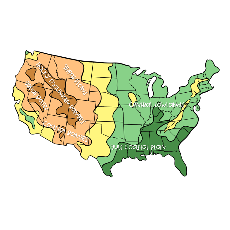
Physical Map of the United States
6
Physical Maps
A physical map shows the natural features and landforms of a certain place. This includes deserts, mountains, plains, valleys, and more. Important and large areas are named on a physical map, including areas above and below sea level. The most common colors used on this type of map are blue, green, and brown. Physical maps are often used by pilots and mountain climbers. These maps are helpful because they help them determine their elevation.
7
Multiple Select
Select two examples of people who use physical maps.
pilots
mountain climbers
cooks
barbers
8
9
Multiple Choice
Physical maps show ______.
natural features
the climate of an area
population of an area
10
Political Map of the United States
11
Political Maps
Political maps show features of an area that are manmade, or created by people. This includes borders, boundaries, cities, capitals, highways, and more. These areas are named and marked on a political map. Bright colors are often used to display the features of a map. This allows the reader to easily locate key areas, such as boundaries between states or countries. Many maps and globes purchased today feature both physical and political features.
12
Multiple Choice
Why are bright colors used on political maps?
To easily locate key areas, such as boundaries between states or countries.
To make the map look better.
13
14
Multiple Choice
Political maps show _______.
borders of countries
mountains in the area
climate of the area
15
Multiple Choice
What is the main difference between physical and political maps?
Political maps show manmade features and physical maps show natural features.
Political maps are colorful and physical maps are not.
Physical features are found on maps and globes.
Physical and Political Maps
Show answer
Auto Play
Slide 1 / 15
SLIDE

Similar Resources on Wayground
10 questions
Article 7: The Dust Bowl
Presentation
•
4th Grade
11 questions
Possessive Pronouns
Presentation
•
5th Grade
11 questions
Shark Week Revising and Editing
Presentation
•
5th Grade
10 questions
Branches of Government
Presentation
•
5th Grade
11 questions
Bill of Rights
Presentation
•
5th Grade
10 questions
Balanced and Unbalanced Forces
Presentation
•
5th Grade
10 questions
A Christmas Carol - part 1
Presentation
•
5th Grade
10 questions
Solids, Liquids and Gases
Presentation
•
5th Grade
Popular Resources on Wayground
24 questions
PBIS-HGMS Day 10
Quiz
•
6th - 8th Grade
10 questions
HCS SCI 03 Summer School Review 3
Quiz
•
3rd Grade
11 questions
Home Scope
Quiz
•
7th - 8th Grade
15 questions
HCS SCI 05 Summer School Assessment 3 Review
Quiz
•
5th Grade
35 questions
Lufkin Road Middle School Student Handbook & Policies Assessment
Quiz
•
7th Grade
18 questions
Geo 11.3 Area of Circles and Sectors
Quiz
•
9th - 11th Grade