Political vs Physical Maps
Presentation
•
Social Studies
•
4th - 5th Grade
•
Hard

Joseph Anderson
FREE Resource
5 Slides • 10 Questions
1
2
Physical maps focus on landforms and elevation. They show mountains, plateaus, rivers, deserts, and any other types of geographical features. Cartographers often use brown, green, or gray color schemes to represent the various physical features and elevations.
3
Many physical maps have a key showing color changes and elevation. On this map, the darker blue represents deeper water and the darker brown represents higher elevations.
4
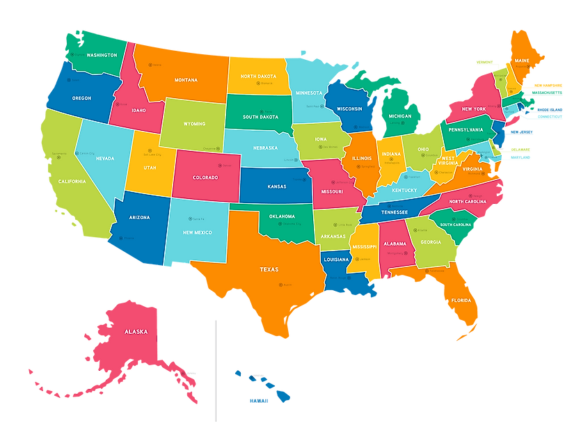
Political maps focus on boundaries between places such as countries, counties, states, provinces, or regions. They may also show major cities, towns, and settlements depending on the purpose of the map.
5
Although political maps do not focus on landforms, they may show some lakes, rivers, and oceans. These physical features are only used to show locations of these landforms. The focus is still on political borders. Like physical maps, political maps also use different colors for different places. The different colors on this map show different states in the USA.
6
Multiple Choice
What type of map focuses on landforms such as rivers, mountains, and deserts?
political
physical
7
Multiple Choice
What type of map shows different elevations in water and on land?
political
physical
8
Multiple Choice
What type of map focuses on borders between states?
political
physical
9
Multiple Choice
What type of map shows cities and towns within a certain state?
political
physical
10
Multiple Choice
This map is an example of a _____ map.
political
physical
11
Multiple Choice
This map is an example of a ____ map.
political
physical
12
Multiple Choice
This map is an example of a ___ map.
political
physical
13
Multiple Choice
This map is an example of a ____ map.
political
physical
14
Multiple Choice
Dylan wants to find out what countries are located in Asia. What type of map should Dylan use?
political
physical
15
Multiple Choice
Ava wants to find the highest mountain range in North America. Which type of map should Ava use?
political
physical
Show answer
Auto Play
Slide 1 / 15
SLIDE

Similar Resources on Wayground
8 questions
The Arab League's members
Presentation
•
4th - 5th Grade
10 questions
Reading A Map
Presentation
•
3rd - 5th Grade
12 questions
What is Social Studies?
Presentation
•
3rd - 6th Grade
10 questions
Metric Conversions
Presentation
•
5th Grade
11 questions
On Becoming a Filipino Citizen
Presentation
•
4th Grade
10 questions
Bering Land Bridge Theory
Presentation
•
5th Grade
13 questions
Canary islands autonomous region
Presentation
•
4th - 5th Grade
13 questions
Weather Maps
Presentation
•
3rd - 5th Grade
Popular Resources on Wayground
10 questions
Safety Day 2026 – Student Review
Quiz
•
9th Grade
21 questions
Continents and Oceans
Quiz
•
6th Grade
20 questions
Parts of Speech
Quiz
•
5th Grade
16 questions
Subject & Predicate
Quiz
•
5th Grade
25 questions
Multiplication Facts
Quiz
•
5th Grade
12 questions
Map Skills
Quiz
•
3rd Grade
22 questions
Continents and Oceans
Quiz
•
5th Grade
15 questions
Rounding Decimals
Quiz
•
5th Grade
Discover more resources for Social Studies
22 questions
Continents and Oceans
Quiz
•
5th Grade
14 questions
Age of Exploration
Quiz
•
4th Grade
50 questions
United States Map
Quiz
•
5th Grade
22 questions
Northeast states and capitals
Quiz
•
4th Grade
9 questions
Hardships In Jamestown Vs.3f
Quiz
•
4th - 5th Grade
11 questions
Northeast Region States
Quiz
•
4th Grade
5 questions
Math GI 2.1.4 Quiz Review
Presentation
•
1st - 5th Grade
7 questions
USII.4a Reasons for Westward Expansion Review
Quiz
•
5th Grade