
Latitude and Longitude
Presentation
•
Geography
•
6th - 8th Grade
•
Practice Problem
•
Medium

Jessica Kweitel
Used 55+ times
FREE Resource
11 Slides • 4 Questions
1
Understanding Location
2
Learning Intentions
To learn about latitude and longitude and important lines on a map
To learn about grid referencing
To learn about latitude and longitude and important lines on a map
3
SUCCESS CRITERIA
I can identify and explain location of places using grid referencing
I know what latitude and longitude is and can identify important lines on a map
I can identify location using latitude and longitude
4
Latitude
Lat is Flat
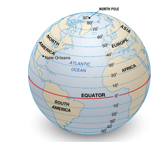
Lines of latitude are imaginary lines that run around the earth’s circumference.
They run parallel to each other so they are known as the parallels of latitude.
The most important line of latitude is the equator and divides the world into North and South.
5
Multiple Choice
Which streets are parallel on the following map of the CBD
Bourke and Elizabeth
Swanston and Exhibition
Russel and Lonsdale
6
Important
Latitude is measured in degrees North and degrees South.
North Pole is 90° N
7
Multiple Choice
what latitude is the Equator?
0 degrees
90 degrees N
90 degrees S
90 degrees W
8
IMPORTANT NOTES
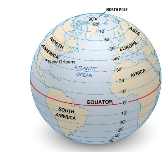
North Pole – 90° N
Arctic Circle – 66.5° N
Tropic of Cancer – 23.5° N
Equator – 0°
Tropic of Capricorn – 23.5° S
Antarctic Circle – 66.5° S
South Pole – 90° S
9
IMPORTANT NOTES
North Pole – 90° N
Arctic Circle – 66.5° N
Tropic of Cancer – 23.5° N
Equator – 0°
Tropic of Capricorn – 23.5° S
Antarctic Circle – 66.5° S
South Pole – 90° S
10
What does changing your latitude change?
Latitude influences CLIMATE
Solar radiation is stronger and more direct at the equator. This means that places at the equator are hotter than places near the Poles.
11
CLIMATE - Draw and label into your book or draw the Key
Tropical is Red
Temerate is green
Polar is light blue
12
Multiple Choice
What does this represent
Longitude
Latitude
Parallels
13
Lines of Longitude
Also called meridians
Run North South direction
0 degrees is the Prime Meridian
Prime Meridian runs through Greenwhich England
Furthest apart at equator and meet at the poles...
Therefore...they are NOT parallel.
14
Multiple Choice
True or False...The Prime Meridian divides the world in East and West
False
True
15
What do meridian lines of longitude do?
Influence time zone
There are 24 hours in a day and 24 time zones. Each zone is 15° wide.
Understanding Location
Show answer
Auto Play
Slide 1 / 15
SLIDE

Similar Resources on Wayground
10 questions
Affect vs Effect
Presentation
•
6th - 8th Grade
10 questions
Organizational Patterns Review
Presentation
•
6th - 8th Grade
10 questions
Chemical Formulas
Presentation
•
6th - 8th Grade
10 questions
Multiplying Integers
Presentation
•
6th - 8th Grade
10 questions
Mechanical and chemical digestion
Presentation
•
6th - 8th Grade
10 questions
2nd 9 Weeks Makeup - Tempo
Presentation
•
6th - 8th Grade
10 questions
Theme Practice with Aesop's Fables
Presentation
•
6th - 8th Grade
11 questions
MR. HELP
Presentation
•
6th - 8th Grade
Popular Resources on Wayground
10 questions
HCS SCI 03 Summer School Review 4
Quiz
•
3rd Grade
11 questions
HSMS - Standard Response Protocol
Quiz
•
6th - 8th Grade
16 questions
1.1-1.2 Quiz Review
Quiz
•
9th - 12th Grade
12 questions
Exponent Expressions
Quiz
•
6th Grade
20 questions
Adding and Subtracting Integers
Quiz
•
6th - 7th Grade
11 questions
Northeast States
Quiz
•
3rd - 4th Grade
10 questions
Characterization
Quiz
•
3rd - 7th Grade
10 questions
Common Denominators
Quiz
•
5th Grade
Discover more resources for Geography
11 questions
HSMS - Standard Response Protocol
Quiz
•
6th - 8th Grade
12 questions
Exponent Expressions
Quiz
•
6th Grade
20 questions
Adding and Subtracting Integers
Quiz
•
6th - 7th Grade
10 questions
Characterization
Quiz
•
3rd - 7th Grade
11 questions
Negative Exponents
Quiz
•
7th - 8th Grade
14 questions
Exponents
Quiz
•
6th Grade