

México - Introducción (geografia y clima

Presentation
•
World Languages
•
9th - 12th Grade
•
Practice Problem
•
Medium

Charles Hinson
Used 32+ times
FREE Resource
12 Slides • 9 Questions
1
México - Introducción geografia y clima

2
México: Introducción - Geografía y clima
With just over 111 million people, México is the home of the largest population of Spanish speakers in the world. Although most people are unaware, the official name of the country is Los Estados Unidos Mexicanos, or in English, the United States of Mexico. Whereas we have 50 states, México consists of 31 states. Let’s look at a map to give us some perspective on things.

3
Fill in the Blanks
4
Multiple Choice
5
México: Introducción - Geografía y clima
As you can see from the map, México is quite a large country. It’s actually the 14th largest country in the world in terms of area and, expectedly, it is incredibly diverse in its geography and climate. Let’s see if we can tackle some of the complexity of this wonderful nation starting with its geography.

6
The southern border of the U.S. is lined with the desert region of the Southwest. Let’s say on your 16th birthday you decide that it’s time to get out of town and really test your driving skills. If you were to drive south toward Texas you could cross into México after around 24 hours of travel. Upon arrival at the border, you would find yourself in an arid desert. Since you’d be getting closer and closer to the equator, you might think that all of México was desert-like and that the country would become progressively hotter.

7
Open Ended
8
Open Ended
9
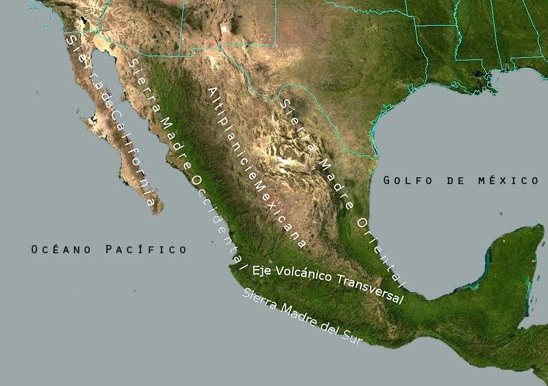
But the Southwestern United States plays a trick on us. As you can see on the topographical map to the right, México has a geography that rivals the U.S. in diversity. Two major mountain ranges, the Sierra Madre Oriental in the east and the Sierra Madre Occidental in the west, line the northeastern and northwestern coasts of the country. In between these two ranges lies the Altiplanicie Mexicana, or the Central Mexican Plateau. Just like España, the central portion of México is on a giant plateau!
10
Fill in the Blanks
11
Multiple Select
12
Further south, is another mountainous zone that is dotted with active volcanoes called el Eje Volcánico Transversal. The capital of México, Ciudad de México, is located in this region. In Spanish, the city is also known as El Distrito Federal, but most Mexicans refer to their capital as “D.F.” (Day-efay) just like we say D.C. for our capital. The city has just over 21 million people and rests majestically at the stunning height of 7,350 ft., even though it is located in a valley between mountains!

13
Multiple Select
14
15
16
17
This might seem difficult, but it’s actually quite easy once you learn the names. We need a landscape with a mountain to make things clear. Let’s look at where each of these regions is found in more detail in a handy chart. The altitudes on the left side are listed in feet above sea level.

18
Open Ended
19
20
México is a prime target for natural disasters. The nation basically straddles two tectonic plates that produce frequent earthquakes. And as if that wasn’t enough, huracanes (hurricanes) are constantly battering the shorelines during the hurricane season. As you’ll see in our future lessons on México, planning a trip to our southern neighbor can be difficult for a number of reasons. At least now you know that in terms of geography and climate, you have every option under the sun.

21
Fill in the Blanks
México - Introducción geografia y clima
Show answer
Auto Play
Slide 1 / 21
SLIDE

