
Map Scale Review
Authored by Jake VanWagner
Geography
7th Grade
CCSS covered
Used 1K+ times


AI Actions
Add similar questions
Adjust reading levels
Convert to real-world scenario
Translate activity
More...
Content View
Student View
11 questions
Show all answers
1.
MULTIPLE CHOICE QUESTION
2 mins • 1 pt

Scale is 1in = 8mi. Hatboro and Smithville are 24 miles apart on the map, how far apart are they?
87 mi
30 in
6 in
3 in
Tags
CCSS.7.RP.A.2C
2.
MULTIPLE CHOICE QUESTION
30 sec • 1 pt
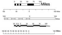
What is the purpose of a map scale?
Tags
CCSS.7.G.A.1
3.
MULTIPLE CHOICE QUESTION
2 mins • 1 pt

Scale: 1in.=7ft. The actual width of the backyard is 49 ft, how wide is it in the drawing?
Tags
CCSS.7.RP.A.2C
4.
MULTIPLE CHOICE QUESTION
2 mins • 1 pt

From Denver to Chicago = 3 in. If the scale is 1 in = 300 miles, find the actual distance.
Tags
CCSS.6.RP.A.3B
5.
MULTIPLE CHOICE QUESTION
1 min • 1 pt

How many miles would 9 inches be on this map?
Tags
CCSS.7.RP.A.2C
6.
MULTIPLE CHOICE QUESTION
45 sec • 1 pt
What is a map scale?
7.
MULTIPLE CHOICE QUESTION
1 min • 1 pt

How many miles would 4 inches be equal to?
Tags
CCSS.6.RP.A.3B


Access all questions and much more by creating a free account
Create resources
Host any resource
Get auto-graded reports

Continue with Google

Continue with Email

Continue with Microsoft
or continue with

%20(1).png)
Apple

Others
Already have an account?

