

Day 3-4 Map Stations

Presentation
•
History
•
7th Grade
•
Hard

Mark Rothfeld
FREE Resource
22 Slides • 20 Questions
1
Open Ended
Why is it important to study region maps and data such as elevation, rivers, climate, economy, and population when learning about Texas?
2

3

4
Multiple Choice
Which of the following rivers is shown flowing through Texas on the map?
Mississippi River
Guadalupe River
Colorado River (outside Texas)
Hudson River
5

6
Multiple Choice
Why are the rivers of Texas referred to as 'wrong way rivers'?
Because they flow from the dry part of the state to the wet part
Because they flow from the wet part of the state to the dry part
Because they flow north instead of south
Because they do not reach the Gulf of Mexico
7

8

9

10
Fill in the Blanks
The main crop grown in the Rio Grande Valley, as mentioned in the Coastal Plains economy, is
11

12
13
Multiple Choice
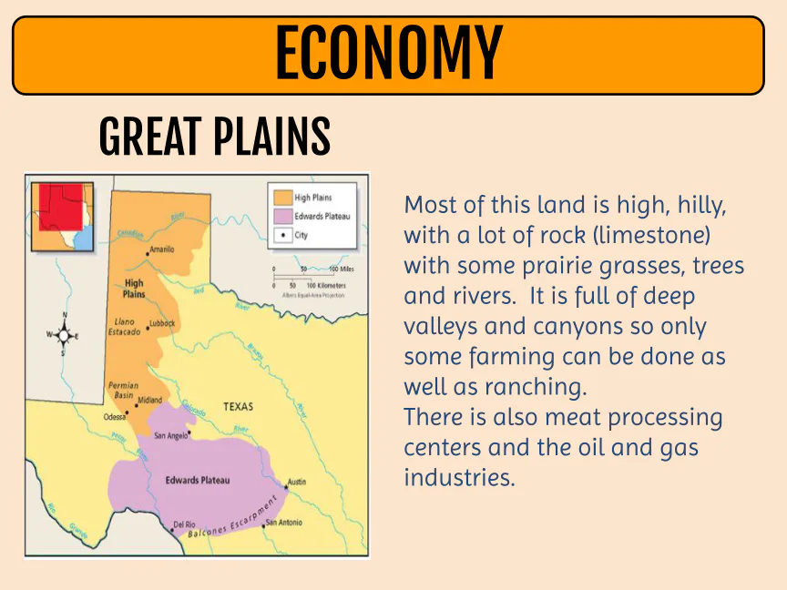
Which Texas region is described as having high, hilly land with deep valleys and canyons, and is known for meat processing centers and oil and gas industries?
Coastal Plains
North Central Plains
Great Plains
Piney Woods
14
Open Ended
How do the physical features and climate of the Great Plains region affect its economic activities?
15

16
Fill in the Blanks
The city of El Paso is located in the
Type answer...
17
Multiple Choice
Which region of Texas is characterized by mountains, basins, and few towns due to its rocky soil and terrain?
Mountains and Basins
Coastal Plains
Great Plains
Central Plains
18

19

20
Multiple Select
Based on the rainfall maps, which of the following statements are true about rainfall patterns in Texas?
Rainfall decreases from east to west.
The eastern part of Texas receives more than 56 inches of rain annually.
The western part of Texas receives less than 20 inches of rain annually.
Rainfall increases from west to east.
21

22
Multiple Choice
Which mineral resource is most widely distributed across Texas according to the Texas Mineral Resources map?
Oil
Coal
Limestone
Natural gas
23

24

25
Open Ended
What can you infer about population distribution in Texas based on the night lights map?
26

27
Multiple Choice
What is one major reason thousands of people have been attracted to Texas in recent years?
Its healthy economy and job opportunities
Its cold winters and mild summers
Its low population density in rural areas
Its lack of highways and infrastructure
28


29
Multiple Choice
Based on the temperature maps and graph, which city in Texas is likely to experience the hottest summers?
Houston
El Paso
Dallas
Lubbock
30

31
Fill in the Blanks
The region of Texas that experiences cooler temperatures year-round due to higher elevation is called the
Type answer...
32

33
Multiple Select
Which of the following factors contribute to the climate differences across Texas regions?
Proximity to the Gulf of Mexico
Elevation changes
Sea breezes
Urban population density
34

35

36
Multiple Select
As you travel from the Gulf Coast to West Texas, which landforms and features will you encounter?
Flat level plains
Rolling hills
Plateaus and canyons
Dense forests
37
Open Ended
Explain how elevation affects the physical geography and climate of Texas as you travel from east to west.
38

39

40
Multiple Choice
How does the elevation change as you move from west to east across Texas, and how might this affect the climate and water availability in different regions of the state?
Elevation increases from west to east, leading to more rainfall in the west.
Elevation decreases from west to east, which may result in more surface water in the east.
Elevation remains the same across Texas, so there is no impact on climate or water.
Elevation increases from west to east, causing more droughts in the east.
41
Open Ended
How do the rivers shown on the map influence the population and economy of Texas?
42
Multiple Choice
Which of the following rivers flows through Texas and empties into the Gulf of Mexico?
Mississippi River
Sabine River
Colorado River (outside Texas)
Rio Grande
Why is it important to study region maps and data such as elevation, rivers, climate, economy, and population when learning about Texas?
Show answer
Auto Play
Slide 1 / 42
OPEN ENDED
Similar Resources on Wayground

35 questions
Unit 2.3 The Executive Branch
Presentation
•
7th Grade
34 questions
Western Expansion: Land Acquisition
Presentation
•
8th Grade
37 questions
The Griots: African History's Unsung Heroes
Presentation
•
7th Grade
37 questions
Perumusan Pancasila sebagai Dasar Negara
Presentation
•
7th Grade
39 questions
Origins of Judaism
Presentation
•
7th Grade
38 questions
1st Nine Weeks Review
Presentation
•
6th Grade
37 questions
Adaptations Animals
Presentation
•
7th Grade
38 questions
Reconstruction Era Notes
Presentation
•
7th Grade
Popular Resources on Wayground
10 questions
Safety Day 2026 – Student Review

Quiz
•
9th Grade
21 questions
Continents and Oceans
Quiz
•
6th Grade
20 questions
Parts of Speech
Quiz
•
5th Grade
16 questions
Subject & Predicate
Quiz
•
5th Grade
25 questions
Multiplication Facts
Quiz
•
5th Grade
12 questions
Map Skills
Quiz
•
3rd Grade
22 questions
Continents and Oceans
Quiz
•
5th Grade
15 questions
Rounding Decimals
Quiz
•
5th Grade
Discover more resources for History
25 questions
The American Revolution
Quiz
•
7th - 10th Grade
30 questions
Foundations of Gov. Test Review
Quiz
•
7th Grade
15 questions
Ancient Rome
Quiz
•
7th - 10th Grade
16 questions
Students of Civics Unit 2: The Constitution
Quiz
•
7th - 11th Grade
14 questions
Lawmaking (CE.2b)
Quiz
•
7th Grade
10 questions
Exploring the 7 Principles of the Constitution

Interactive video
•
6th - 10th Grade
10 questions
Significance of the Declaration of Independence
Interactive video
•
6th - 10th Grade
20 questions
Quiz on Spanish and Mexican Colonization
Quiz
•
7th Grade