Search Header Logo
Physical Geography of Russia and the Eurasian Republics

Physical Geography of Russia and the Eurasian Republics

Assessment

Presentation

Social Studies

6th - 8th Grade

Easy

Created by

Melissa Davis

Used 13+ times

FREE Resource

17 Slides • 9 Questions

1

Physical Geography of Russia and the Eurasian Republics

​Objectives/Goals

​Vocabulary

  • Identify the physical geographic features of Russia and the Eurasian republics

  • Explain the limitations these geographical features create


  • Crossroads

  • Endemic

  • Herding

  • Irrigate

  • Peninsula

  • Siberia

​Essential Questions: What are the main physical features of Russia and the Eurasian republic?

media

2

Open Ended

Question image

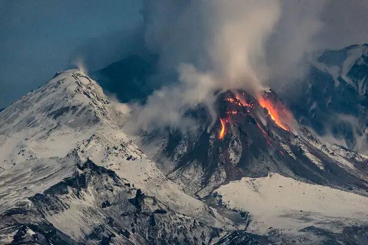
Where in the World is Comet?

(Specific Location, Region, and Country)

Clue 1: This location is located on the Kamchatka Peninsula

Clue 2: This location is a UNESCO World Heritage Site.

Clue 3: There are more than 300 of these in this region but only about 29 of these are active.

Clue 4: This specific location is called "Suelich", which means "Smoking Mountain".

Clue 5: The last activity at this location was on August 18, 2024.

Where in the world is Comet?

3

Poll
Question image

Have you ever heard of the R.A.C.E.S writing strategies?

4

Open Ended

Question image

What do you think the "R" in the R.A.C.E.S writing strategy stands for?

5

Open Ended

Question image

What do you think the "A" in the R.A.C.E.S writing strategy stands for?

6

R.A.C.E.S. Writing Strategy

Response to Document-Based Questions

media

7

Word Cloud

Question image

What is one PHYSICAL GEOGRAPHY word that you would use to describe Russia?

8

Russia is HUGE!

media

9

​Russia and the Eurasian Republics

  • Eurasia: the landmass that contains the continents of Europe and Asia.

    • Russia is the largest country in the world by landmass

      • 11 different time zones

      • Siberia is known for it's harsh climate

    • Eurasian Republics lie south of Russia

      • Include the countries of Kazakhstan, Kyrgyzstan, Tajikistan, Turkmenistan, Uzbekistan, Armenia, Azerbaijan, Georgia, and Belarus

      • Persian (Farsi) and Urdu language, 'stan' means 'land of'.

      • Eurasian Republics (Central Asia) have historically been known as the "Crossroads of Europe and Asia"

        • Crossroads: intersection of two or more roads

media
media
media
media

10

11

media
media

​Time Zones in Russia

  • Russia’s physical size creates a challenge because Russia covers multiple time zones, coordination across the area can be difficult. 

  • Time Zones divide the world into 24 time zones

  • GMT (Greenwich Mean Time) is the start of the time zones

    • The further away you get from GMT is plus or minus the time, based on which direction you travel.

      • 1 pm in London = 4 pm in Moscow

      • 5 pm in Moscow = 5 pm in Izhevsk

12

Multiple Choice

Question image

If it is 1 pm in Moscow, what time will it be in Norilsk?

1

6 pm

2

4 pm

3

8 pm

13

Multiple Choice

Question image

How does Russia's physical size create a challenge?

1

Because Russia has so many cultures, the government requires that everyone speak the same language.russiaRuss

2

Because Russia has mountains, tourists come to visit.

3

Because Russia is so large, the government has decided to use different types of money in different areas.

4

Because Russia covers multiple time zones, coordination across the area can be difficult.

14

​Physical Geography of the Region

  • Western Russia

    • 1/4 of Russia's total land

    • 3/4 of Russia's population

    • Major cities of Russia, including Moscow

    • Warmer Climate

    • More Vegetation

  • Eastern Russia

    • 40 million people live here

    • Includes Lake Baikal

    • Includes Norilsk (200,000 people)

    • Includes most of Siberia

      • Siberia: a vast portion of eastern Russia and northern Kazakhstan

        • Known for its HARSH landscape and low population (36 million people)

        • Some of the coldest places in the Northern Hemisphere (-89.9 degrees)

media
media
media
media

15

​Peninsulas of the Region

  • Kola Peninsula

    • The far Western side of Russia

    • North Atlantic Current brings warmer water and air to the peninsula making the temperature warmer

    • Popular for Salmon fishing

    • Rich in Mineral resources

  • Kamchatka Peninsula

    • The far eastern side of Russia

    • Thermal Springs, Volcanoes and Glaciers

    • Located on the Ring of Fire

media
media
media
media
media
media

16

Mountains and Plateaus of the Region

  • Ural Mountains

    • a natural boundary between the two continents of Europe and Asia

    • filled with natural resources (iron ore, natural gas, and oil)

  • Caucasus Mountains

    • highest peak in Russia - Mt. Elbrus

    • known for herding (keeping and looking after livestock for food and animal by-products)

  • Altai Mountains

    • a natural border between Russia, Mongolia, China, and Kazakhstan

    • many people are nomadic herders

    • home to unique animals that have been around since the ice age

  • Sayan, Yablonovy, and Stanovoy Mountain ranges form natural borders between Russia and Southeast Asia

  • Central Siberian Plateau

    • Yenisey River has created large canyons

media
media
media

17

​Plains of the Region

  • Northern European Plain/Russian Plain

    • North Part: Flat with poor drainage - Swamps and lakes

    • South Part: rich black soil (good for crops)

      • 75% of Russia's population live here

  • West Siberian Plain

    • East of the Ural Mountains

    • one of the world's largest flat lands

    • Swampy and marshes

  • The Steppes

    • southeastern Eurasia (mostly in Kazakhstan)

    • grasslands; few trees

    • Farmland with irrigation systems

    • great for herding

media
media
media
media
media
media

18

19

Draw

Locate the Northern European Plain/Russian Plain

Locate the Siberian Plain

Locate the Steppes

20

​Seas and Lakes of the Region

  • The Black Sea

    • major source of transportation of Russian ships to reach the Aegean and Mediterranean Sea

  • The Caspian Sea

    • the largest inland body of water

    • salt water with no access to the ocean

    • many oil reserves

  • Lake Balkhash

    • largest lake in Central Asia

    • shrinking due to the overuse of water for irrigation

  • Lake Baikal

    • located in southern Siberia

    • deepest freshwater lake in the world

    • many endemic species (only found in this lake)

media
media
media
media
media
media
media
media

21

22

​The Aral Sea

  • What makes the Aral Sea important?

    • It USED to be the largest lake in Kazakhstan and Uzbekistan

    • It USED to be the 4th largest lake in the world

    • The Aral Sea has decreased in size due to overuse of irrigation (water supplied to farms)

  • Consequences/ "Why Should I Care?"

    • Salt water left behind has evaporated into the wind causing major health issues

    • Sandstorms from the dry seabed

    • Fertilizers and Pesticides have destroyed the habitats of plants, animals, and people

    • The fishing industry is destroyed

  • Can we fix it?

    • Dams to direct fresh water to the Aral Sea

    • Laws and regulations to protect what is left

media
media
media

23

24

Rivers of the Region

  • Volga River

    • nicknamed "Mother Volga"

    • Helps drain the land in the Northern European Plan for crops and infrastructure

    • connects major cities, such as Mosco to the Black Sea and Caspian Sea

    • Hydroelectric Dams/Power Plants are a major source of electricity in this region (Moscow and Volgograd)

  • Ob River

    • A major source for the fishing industry

    • Vasyugan Swamp: largest swamp in the Northern Hemisphere

  • Yenisey River

    • largest river to drain into the Arctic Ocean

    • main way to travel through Siberia

  • Irtysh River

    • tributary of the Ob River; the longest tributary in the world

  • Lena River

    • covered in ice for 7 months of the year

media
media
media

25

​Russia and the Arctic

  • More than one-fifth of the land mass of Russia is in the Arctic Circle.

    • Russia is the only country to have a city located precisely on the Arctic Circle

      • Salekhard; population - 50,000

    • Drift Stations

      • Countries build temporary structures to research ice floes (floating ice that is more than 60 feet across and is not attached to the shore

      • study climate, melting sea ice, animal ecosystems, weather patterns, ocean currents and ice floes

  • Valuable Shipping Corridor

    • transport goods from the Barents Sea to the Bering Straig

    • only accessible 8 weeks of the year when ice is low and thin enough

    • Ice-breaking ships must cut through this ice to make the journey

media
media
media
media

26

Open Ended

Question image

Choose one place in Russia or the Eurasian Republics where you would want to visit.

Where and Why?

Physical Geography of Russia and the Eurasian Republics

​Objectives/Goals

​Vocabulary

  • Identify the physical geographic features of Russia and the Eurasian republics

  • Explain the limitations these geographical features create


  • Crossroads

  • Endemic

  • Herding

  • Irrigate

  • Peninsula

  • Siberia

​Essential Questions: What are the main physical features of Russia and the Eurasian republic?

media

Show answer

Auto Play

Slide 1 / 26

SLIDE