Search Header Logo
topography Staar Review Day 10

topography Staar Review Day 10

Assessment

Presentation

•

Science

•

•

Practice Problem

•

Easy

•
NGSS
MS-ESS2-4, MS-ESS2-3

Standards-aligned

Created by

Alex Davila

Used 13+ times

FREE Resource

9 Slides • 14 Questions

1

Topographic Maps
media

2

Topographic Map

View from above

Shows elevation above sea level

Show shape of land

media

3

media

4

media

5

media

6

Multiple Choice

Question image

Observe the image. Between which 2 points is the slope steeper?

1

A to B

2

C to D

7

Multiple Choice

Question image

Which side is steeper?

1

The left side of the hill

2

The right side of the hill

8

Multiple Choice

Question image

If the lines are far apart, it means it is a slow or ________________ rise/drop

1

Gradual

2

Steep

9

media

10

Multiple Choice

Question image

How many peaks does this landform have?

1

None

2

1

3

2

4

3

11

Fill in the Blanks

media image

How many peaks does this mountain have?

Type answer...

12

media

13

Multiple Choice

Question image

Which direction is the river flowing on this topo map?

1

Northeast

2

Southwest

3

East

4

North

14

Contour Lines
  • Each line will increase or decrease

  • The contour interval is how much it increases by

media

15

Multiple Choice

Question image

What is the elevation of Point A

1

15 meters

2

10 meters

3

20 meters

4

30 meters

16

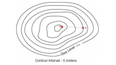
Difference in elevation

To find the difference between 2 points, you get their values and subtract

media

17

Multiple Choice

Question image

What is the difference in elevation between point A and B?

1

760 m

2

820 m

3

60 m

4

20 m

18

Multiple Choice

Question image
Which topographic map matches formation C?
1

1

2

2

3

3

4

4

19

Multiple Choice

If contour lines are close together, then the slope is
1

gentle

2

steep

3

flat

4

going up and down

20

Multiple Choice

Question image

What is the elevation of point B?

1

800 ft

2

850 ft

3

900 ft

4

1000 ft

21

Multiple Choice

Question image

Determine the contour interval:

1

5 m

2

10 m

3

15 m

4

20 m

22

Multiple Choice

Question image

Match the topographic map to its profile.

1
2
3
4

23

Multiple Choice

Question image

If the lines are close together on the map, it means that the rise/drop is ________________

1

Steep

2

Gradual

pattern-tertiary
Topographic Maps
media

Show answer

Auto Play

Slide 1 / 23

SLIDE