

The 5 Basic Shapes of Countries

Presentation
•
Geography, Social Studies
•
7th Grade
•
Practice Problem
•
Medium

Mark Thompson
Used 19+ times
FREE Resource
8 Slides • 17 Questions
1
The 5 Basic Shapes of States
Compact, Protruded, Elongated, Perforated and Fragmented

2
The Shapes of States
In political geography, a "state" is the same as a country.
Geographic characteristics of a state include size, shape, location.
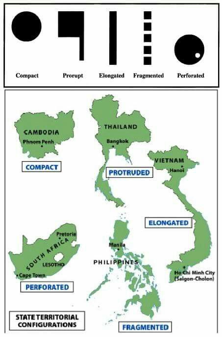
The 5 basic shapes of states are compact, protruded, elongated, perforated and fragmented.
The shape of a state can affect communication and conflict.
3
Compact states
a state shaped like circle/square
center is about same distance (equidistant) to the borders
capital should ideally be in center
good communication, shortest boundaries to defend
Kenya and Poland are examples

4
Prorupted states
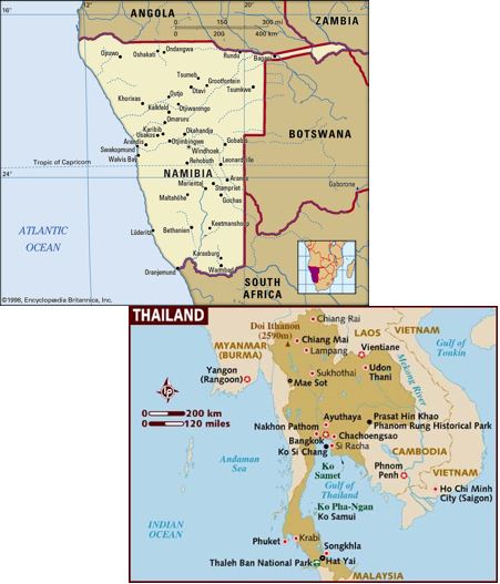
compact with a large extension that projects from it
proruptions (extensions) created for two reasons: access to natural resource, separate two states that would otherwise share a border
also called a protruded state
Namibia/Thailand are examples
5
Elongated states
states with long, narrow shape
may suffer from poor internal communication/transportation
region at one end may be isolated
capital may lose influence over the isolated end
Chile and Vietnam and examples

6
Perforated states
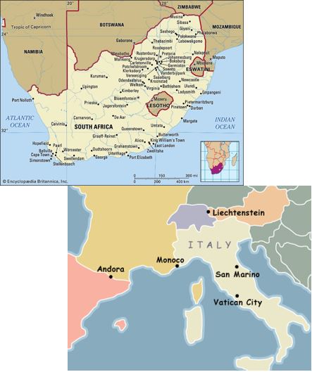
a state that completely surrounds another state
relationship between perforated state and the state it surrounds can cause tensions
South Africa surrounds Lesotho
Italy surrounds the microstates of San Marino and Vatican City
7
Fragmented states
a state that is broken up into multiple pieces that are separated
can be difficult to maintain unity and good communication
Indonesia and the Philippines are the most extreme examples

8
Landlocked states
location also impacts a country
landlocked countries have no access to the sea (no coastline)
this makes overseas trade difficult, so most landlocked states are developing countries

9
Multiple Choice

This is a map of Africa. Which number correctly identifies a country that is landlocked?
10
Multiple Choice

Which number correctly identifies a country that is NOT compact?
11
Multiple Choice

What would be the best title for this map?
12
Multiple Choice

Which shape is this country?
13
Multiple Choice

Which shape is this country?
14
Multiple Choice

Which shape is the country highlighted on this map?
15
Multiple Choice

Which shape is the country highlighted on this map?
16
Multiple Choice

This is a map of Southeast Asia. Which shape is NOT represented by one of the countries in Southeast Asia?
17
Multiple Choice

Which shape is the country highlighted on this map?
18
Multiple Choice

Which shape is the country highlighted on this map?
19
Multiple Choice

Which shape is the country highlighted on this map?
20
Multiple Choice

Which shape is the country highlighted on this map?
21
Multiple Choice

This is a map of Southeast Asia. What is the only landlocked nation in Southeast Asia?
22
Multiple Choice

This is a map of Central Asia. According to this map, which statement is true?
23
Multiple Choice

This is a map of Italy. Which shape is Italy?
24
Multiple Select

This is a map of South America. Which countries in South America are landlocked? Check two that apply.
25
Multiple Choice

This is a map of the United States. What shape is the United States?
The 5 Basic Shapes of States
Compact, Protruded, Elongated, Perforated and Fragmented
Show answer
Auto Play
Slide 1 / 25
SLIDE

